F&F Micro Advanced Online
Subdivision Plat Viewer
Your Gateway to Precise Property Data
DOWNLOAD
Welcome to the F&F Micro Subdivision Plat Viewer, a powerful and intuitive online tool meticulously designed to transform how you access and interact with critical property information. Developed with precision and user-friendliness in mind, our viewer is the go-to resource for Title Companies, Engineering & Surveying Professionals, Real Estate Agents, Land Developers, Legal Professionals, and even property enthusiasts who demand accurate and detailed access to subdivision plats across Texas.
Key Features & Unmatched Usability
The F&F Micro Subdivision Plat Viewer is built with features designed to enhance your research and streamline your workflow:
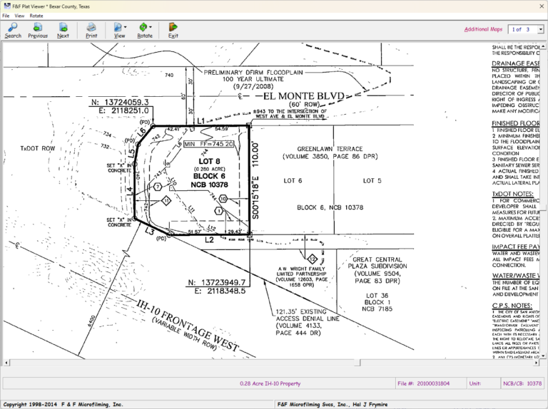
- Seamless Viewing & Navigation: Our intuitive interface allows for effortless Browse through countless subdivision plats. You can quickly locate specific plats, navigate between pages, and get a clear overview of the land’s historical and current layout.
- Precision Zoom Functionality: Dive deep into the details with our advanced zoom capabilities. Examine intricate boundary lines, lot numbers, easements, and other critical annotations on every plat image with exceptional clarity, ensuring you don’t miss any vital information.
- High-Quality TIFF Image Access: We provide access to high-resolution TIFF images, preserving the integrity and detail of the original documents. This ensures that every line, label, and annotation is sharp and readable, crucial for legal and professional applications.
- Effortless Printing Options: Need a hard copy for your records or client presentations? Our viewer enables you to print high-quality versions of the plats directly from your browser, giving you tangible documents whenever necessary.
- Cross-County Coverage: Our comprehensive database includes a wide array of Texas counties, from the bustling metropolitan areas to the more rural regions. This expansive coverage makes it a centralized resource for professionals working across diverse geographical areas.
This powerful tool not only saves invaluable time previously spent on manual record searches but also significantly reduces the risk of errors associated with outdated or incomplete information. By providing immediate, digital access to precise subdivision plat details, our viewer empowers users to make more informed decisions faster, leading to streamlined workflows and enhanced project accuracy. Its intuitive interface means less time learning and more time getting the crucial data you need.
Transforming Research & Decision-Making
The F&F Micro Online Plat Viewer simplifies the often complex and time-consuming process of accessing vital property information. Whether your needs are legal, real estate, land development, surveying, or personal research, our viewer provides a reliable, efficient, and user-friendly experience.
- For Title Companies: Quickly verify parcel boundaries, ownership history, and potential easements with unparalleled accuracy, accelerating your due diligence process.
- For Engineering & Surveying Companies: Access precise plat details essential for site planning, boundary verification, and project execution, ensuring the accuracy of your designs and surveys.
- For Real Estate Professionals: Provide clients with immediate access to property plat details, enhancing transparency and speeding up transactions.
- For Land Developers: Evaluate potential sites, understand existing subdivisions, and plan new developments with confidence, leveraging accurate spatial data.
- For Personal Research: Homeowners and curious individuals can easily access information about their property and neighborhood, gaining a deeper understanding of their land.
At F&F Micro, we are committed to ensuring you have all the precise subdivision plat details you need at your fingertips, empowering you with accurate information for every critical decision.
Counties Served by F&F Micro Subdivision Plat Viewer
We consistently update our database to ensure you have access to the most current and comprehensive collection of Texas subdivision plats. Our commitment to data integrity means each TIFF image is processed to maintain clarity and accuracy, reflecting the true nature of the original documents. This meticulous approach guarantees that whether you’re performing legal research, assessing potential development sites, or verifying property boundaries, the information you retrieve is dependable and authoritative.
Counties: Atascosa, Bandera, Bastrop, Bexar, Blanco, Brazoria, Cameron, Collin, Comal, Dallas, Denton, Ellis, Ft. Bend, Guadalupe, Hays, Hidaldgo, Johnson, Kendall, Kerr, Live Oak, Llano, McMullen, Medina, Montgomery, Nueces, Parker, Rockwall, San Patricio, Tarrant, Travis, Uvalde, Williamson, Wilson