- 202300259144 01-2024
- 202400019051 02-2024
- 202400040922 03-2024
- 202400062455 04-2024
- 202400085975 05-2024
- 202400109020 06-2024
- 202400128018 07-2024
- 202400153214 08-2024
- 202400176053 09-2024
- 202400196632 10-2024
- 202400220852 11-2024
- 202400240481 12-2024
- 202400246070 01-2025
- 202500019852 02-2025
- 202500040296 03-2025
- 202500062972 04-2025
- 202500086772 05-2025
- 202500112097 06-2025
- 202500180975 09-2025
- 202600019523 02-2026
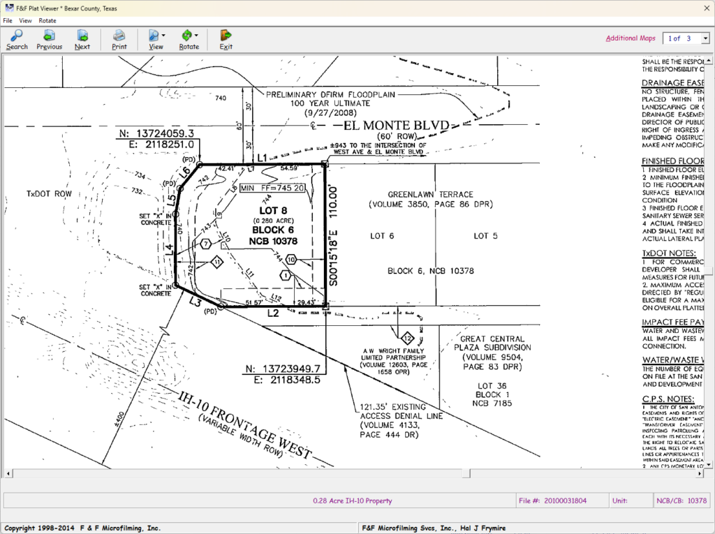
Our cutting-edge Subdivision Plat Viewer for Dallas is meticulously designed to cater to the demanding requirements of various professionals and enthusiasts in the real estate, surveying, and legal sectors. This sophisticated online tool serves as an indispensable resource for Title Companies, Engineers, Surveying Company Professionals, and individuals who necessitate precise and detailed access to subdivision plats. In a world increasingly reliant on readily available information, our viewer stands out as a robust and intuitive solution, bridging the gap between complex legal documents and user accessibility.
The core functionality of our advanced platform empowers users to seamlessly view high-quality TIFF images of maps and plats. This includes detailed information for both larger and smaller Texas Counties, offering comprehensive coverage that might be difficult to obtain through traditional methods. The ability to zoom into these high-resolution images allows for granular examination of property lines, easements, rights-of-way, and other critical details that define a particular subdivision. Furthermore, the printing capability ensures that users can obtain physical copies of these essential documents for various purposes, from internal record-keeping to client presentations.
Our Online Plat Viewer is not merely a display tool; it is engineered with features that significantly enhance usability and improve overall accessibility. The intuitive interface and streamlined navigation make it easy for users, regardless of their technical expertise, to quickly locate and interpret the necessary information. This user-centric approach simplifies the often-complex process of accessing vital property information, saving valuable time and resources for professionals and individuals alike.
For legal professionals, the Plat Viewer provides a reliable source for validating property descriptions, identifying easements or encroachments, and resolving boundary disputes. In real estate, the platform supports informed decision-making by offering clear visual representations of lot dimensions, infrastructure, and potential restrictions, which are crucial during property transactions and development planning. For personal research, whether for potential property purchases or gaining a better understanding of neighborhood layouts, the Plat Viewer delivers an efficient and user-friendly experience, putting all the necessary details at your fingertips.
The platform ensures that users have immediate access to comprehensive data, including lot dimensions, building setbacks, street names, utility easements, and more, as recorded on the official subdivision plats. This depth of detail is crucial for ensuring compliance with zoning regulations and building codes, avoiding costly mistakes, and making well-informed decisions regarding property use and development. By providing a singular, reliable source for these critical documents, our Plat Viewer eliminates the need to visit multiple governmental offices or rely on potentially outdated information, making it an invaluable asset for anyone involved with property in Texas. The efficiency and accuracy offered by our Online Plat Viewer represent a significant advancement in accessing and utilizing subdivision plat information.
Our advanced Subdivision Plat Viewer is designed to meet the needs of Title Companies, Engineers & Surveying Company Professionals and enthusiasts alike who require precise and detailed access to Subdivision Plats. This robust online tool enables users to seamlessly view, zoom, and print high-quality TIFF images of maps and plats for larger and smaller Texas Counties. With features that enhance usability and improve accessibility, our Online Plat Viewer simplifies the process of accessing vital property information. Whether for legal, real estate, or personal research, our Plat Viewer provides a reliable, efficient, and user-friendly experience, ensuring that you have all the details you need at your fingertips.